South Arapaho Peak is an incredible hike, located just 1.5 hours from Denver. Nestled in the Indian Peaks Wilderness of Colorado’s Front Range, this thirteener won’t disappoint!
Elevation: 13,397 ft (13,408 ft by new measurements)
Trail Length: 8.4 miles roundtrip
Elevation Gain: about 3,250 ft
VIDEO
FIRST ENCOUNTER WITH ARAPAHO PEAK
Several years ago I visited a friend in Boulder, Colorado, and ventured to the Indian Peaks Wilderness to do some backpacking. It was on this journey that I first spotted South Arapaho Peak and it seemed like an easy-enough day hike. However, I had not allowed myself enough time to acclimate to the higher elevations and had to opt for the much easier climb up to Arapaho Pass instead. Nevertheless, the mountain stuck in my head.
Fast forward to last summer when I ventured to Denver, CO to hike part of the Colorado Trail with my cousin. This time, I knew I needed to spend some time acclimating to the elevation and so I embarked on several day hikes to prep, one of which marked my return to Arapaho!

HIKING SOUTH ARAPAHO PEAK
Located just 1.5 hours from Denver, South Arapaho Peak is quite easy to reach. The trail begins at the Fourth of July Trailhead which features a parking area and restroom. The parking area fits maybe 20 vehicles but there are parking spaces along the Fourth of July Road as well. This 8-mile road is unpaved but four-wheel drive is not necessary.

Once at the trailhead, follow the gradual Arapaho Pass Trail as it ascends into the Indian Peaks Wilderness. I hiked in early July so the wildflowers were stunning!

Along the way there is a large stream/waterfall to cross that only adds to the enchantment. At some point you will pass a junction for the Diamond Lake Trail but continue on the Arapaho Pass Trail.

Eventually, the trail reaches the Fourth of July Mine, featuring a large hole in the ground and several remnants of mining equipment. Amazing view of Arapaho Peak can be seen from this area.

From here, there will be another stream/marshy area and a sign for the Arapaho Glacier Trail. Leave the Arapaho Pass Trail and turn on to the Arapaho Glacier Trail, slowly climbing above treeline.


As the trail climbs ever higher, the views become more and more stunning with 180º panoramic views. The trail gently switchbacks higher and higher, lined with wildflowers.

Eventually the trail reached the saddle at around 12,700 ft. At this point, the Arapaho Glacier, the largest glacier in Colorado, can be viewed on the other side of the ridge.


From the saddle the the trail becomes a bit more technical with a rock scramble to the summit. Cairns mark the route to the summit featuring a Class 2 scramble as the trail follows the ridge.

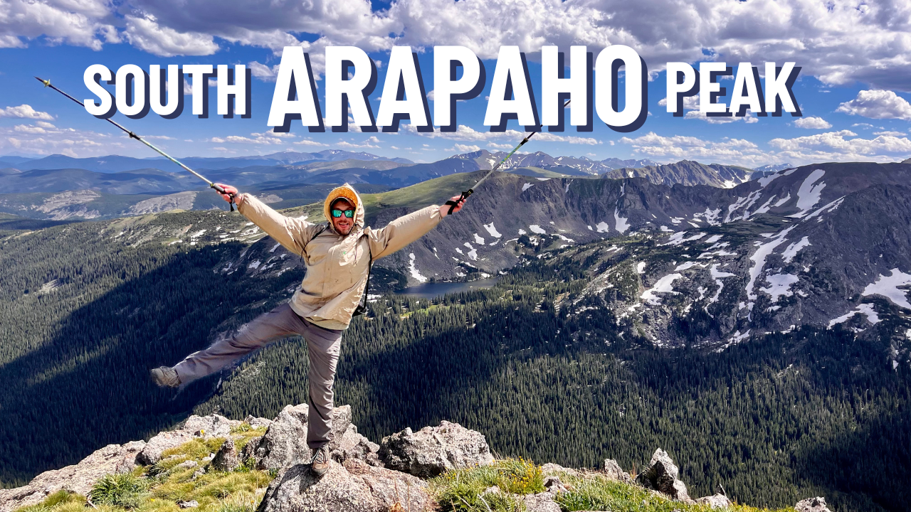
At last the summit of South Arapaho Peak is reached at 13,397 ft. The view from the top is incredible with 360º views of the Indian Peaks Wilderness. The closest peak is the slightly taller North Arapaho Peak at 13,508 ft. The ridge connects the two peaks but it requires a Class 4 traverse which is above my skill level. Longs Peak can also be viewed in the distance.

A small shelter wall of rocks has been built where an engraved metal disc marks the nearby peaks. Following the Arapaho Glacier down, several lakes and a reservoir can be seen, which supply the water to the city of Boulder.

The descent from the summit is simple, returning the way we came. One the saddle is reached the trail is relatively gentle and the views are stunning, looking out into the Indian Peaks Wilderness.

WHY YOU SHOULD HIKE ARAPAHO PEAK
Overall, South Arapaho Peak is an amazingly beautiful hike. The trail is less than a 2 hour drive from Denver and doesn’t draw the crowds like the 14,000 ft peaks do. The gentle elevation gain makes this an easy hike for beginners, save for the rock scramble near the top. The views are fantastic and there isn’t really anything negative I can see about this hike, save for the small parking lot!
I highly recommend this hike for those visiting Denver and wanting to stray away from the more popular peaks! And for more details on this route, check out this page.
From apparel to prints, grab some awesome trail merch at the A Stray Life Shop!
To follow along with my adventures, sign up via email below or like/follow on Facebook, Instagram, and YouTube:
Leave a Reply